The entire eastern seaboard of the United States should prepare for Irene, a large and dangerous hurricane churning northwestward over the tropical waters of the Caribbean, a senior official warned Tuesday.
After lashing the Turks and Caicos islands and the Bahamas, Irene is projected to skirt Florida and instead hit the Carolina coast by the weekend, Federal Emergency Management Agency administrator Craig Fugate said.
Irene's exact path cannot be predicted this far out, Fugate added, noting the storm will affect a large area.
"People think hurricanes are a Southern thing but people in the mid-Atlantic and Northeast need to take Irene seriously," Fugate said. "We have a lot of time for people to get ready but we don't have forever."
Emergency officials in southeastern states have already stepped up operations in preparation for the first significant storm to threaten the United States in three years.
North Carolina's coastal Ocracoke and Hyde counties have declared a state of emergency starting at 5 a.m. Wednesday. Officials declared a mandatory evacuation for all visitors and residents starting at 5 a.m. Thursday.
Irene became a Category 2 hurricane Monday evening with maximum sustained winds of 100 mph, but now moving at a stately 12 miles per hour, Irene is expected to strengthen to a Category 3 by Wednesday. That would make it a major hurricane, forecasters say, and then approach Category 4 status as it gathers steam and organizes over the warm ocean.
"We see no reason for it not to be a major hurricane," said Bill Read, director of the Miami-based National Hurricane Center. He said the Atlantic up to Cape Hatteras in North Carolina is warm enough to sustain a major hurricane.
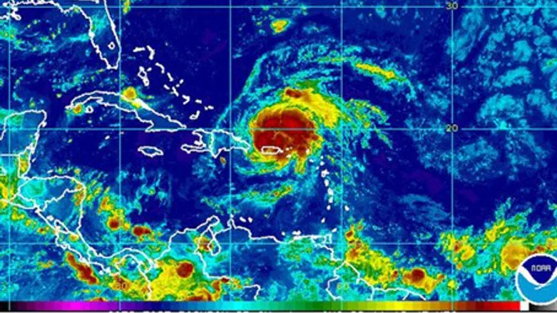
Tuesday, Irene took aim at the Turks and Caicos islands after lashing the Dominican Republic with 100 mph winds and heavy rain. It is expected to reach the southeastern and central Bahamas by early Wednesday.
At 11 a.m. Tuesday, the storm was centered about 70 miles south of Grand Turk island and about 50 miles north-northwest of Puerto Plata in the Dominican Republic, the Hurricane Center said.
Forecasters said Irene could bring another 4 to 8 inches of rain to the Dominican Republic and Haiti, with as much as 15 inches in higher elevations. Potentially dangerous flooding and mudslides were a threat, the center said.
Rainfall accumulations of 5 to 10 inches are expected in the southeastern and central Bahamas and in the Turks and Caicos islands, it said.
In Puerto Rico, the storm left widespread damage and about 600,000 of the island's 1 million electricity customers were without power, Gov. Luis Fortuno said Monday.
President Barack Obama signed an emergency declaration for Puerto Rico, which will allow for federal disaster assistance to the U.S. commonwealth.
Hurricane warnings were in effect for the southeastern, central and northwestern Bahamas and Turks and Caicos. Hurricane watches were up for the north coast of Haiti east to the Dominican border, while tropical storm warnings were in effect for much of the rest of the Dominican Republic and Haiti.